Maritime surveillance: How Airbus keeps our oceans safe

Our oceans are not only a vital ecosystem but also a powerful economic driver. However, their vast size, combined with the increasing number of movements and activities, makes it increasingly difficult for governments, coast guards, border patrols, and environmental agencies to keep track of what is happening at sea.
Airbus solutions are helping to preserve and keep our oceans safe. Whether on land, in the air, or in space, we provide our customers with the maritime surveillance solutions they need.
SPATIONAV: Monitoring the French coastline

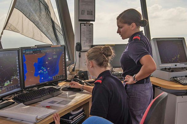
For more than 20 years, the French Navy has been closely collaborating with Airbus on its maritime surveillance missions. At the core stands SPATIONAV, a digital coastal surveillance system that provides the French authorities (Navy, coast guards and customs) with a detailed picture of what is happening at sea.
SPATIONAV draws on a vast network of cameras, radars and other sensors distributed along the coasts of mainland France and overseas departments such as Mayotte and French Guiana. "The setup consists of 105 sites along the French coastline, covering 6,000 kilometres", says Nicolas L., Programme Officer for SPATIONAV at the French Navy.
The data from all these sensors comes together in the SPATIONAV information system, based on Airbus' STYRIS solution. "With SPATIONAV, we can track the routes of ships at sea, receive additional information, such as their names, and share the level of the evaluated risk," Nicolas L. explains. "For instance, we can detect if a ship is moving too fast, if it is approaching a restricted area or if it is getting too close to another vessel."
This is all in the name of safer oceans: "SPATIONAV quickly alerts us of suspicious behaviour, including illegal immigration, drug trafficking and illegal fishing. The solution helps to maintain the integrity of marine protected areas by spotting unwanted intruders and, more importantly, ensure our coasts’ safety.”
For Commander Nicolas L. and his team, fast decision-making is key in maritime surveillance. "Depending on the situation, we must decide quickly whether to alert the coast guards, send out patrol aircraft, or search and rescue vessels." Other times, it is as simple as sending a voice message to a vessel transporting dangerous cargo. "As a real-time monitoring system, we rely on SPATIONAV to ensure that the French coast is secure,” Nicolas L. concludes.
C295: Tackling pollution in Irish waters

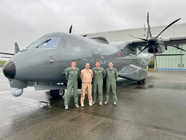
The Irish Air Corps has a huge body of water to monitor, stretching more than 132,000 square nautical miles. Since 2023, the Irish Air Corps has been operating two C295s in a maritime surveillance configuration (MSA) to conduct maritime defence and security operations and to regularly patrol the Irish Exclusive Economic Zone (EEZ).
On a standard mission, the C295 leaves in the morning and returns in the afternoon, after a six-hour patrol. One main task is protecting fisheries, but pollution control also plays an important role. "When the Coast Guards receives satellite reports that there may be pollution, we are asked to investigate," says Donal Curran, 101 Squadron Commander and C295 pilot with the Irish Air Corps.
Enter the Irish C295's Sea Pollution Detection System (SPDS): The aircraft is equipped with an infrared laser that scans the sea surface, reducing the manual effort required to determine what is happening at sea. "We can fly over the target area and switch on the SPDS. Depending on the altitude, we are covering around a 45-metre patch. The system will determine the pollution’s depth and likely composition," Commandant Curran explains.
This information is then automatically entered into the Fully Integrated Tactical System (FITS) reporting form and can be sent directly to the Irish Coast Guard, which is responsible for monitoring pollution in Irish waters. “It’s a very handy tool, and we're already getting really good feedback from the Coast Guards how helpful it's being,” Commandant Curran says.
“Ireland is a small country with relatively few defence resources. So, the more we can do with our aircraft, the more value we can give back to the state.” Donal Curran, 101 Squadron Commander and C295 pilot with the Irish Air Corps.
Getting the full picture from space

With our oceans covering such vast areas, maritime surveillance from the ground and from the air is, in some cases, simply not enough. "Coastal radars or patrol boats can only cover a limited area," says Tim Pattison, Programme Manager at Airbus Defence and Space in the UK. "This makes it particularly difficult to monitor remote locations or vast stretches of ocean effectively."
That is why Airbus satellites help navies, coast guards and other stakeholders to get a complete picture of the situation at sea. "In the UK, we are focusing on vessel detection at the moment," Pattison says. "We're building on our constellation consisting of optical satellites like Pléiades Neo, radar sensors like TerraSAR-X and PAZ, as well as partner sensors including HawkEye360 that provides radio frequency data." Once the customer has identified an area of interest, a tasking plan is drawn up, and the customer is offered a number of options to get the information they require.
The targets detected in the satellite images are matched with vessel traffic data from the Automatic Identification System (AIS) to identify the ships. If no AIS data is available, they are classified as dark targets. "Our customers then use this information to plan further action," explains Pattison. "For example, they may send a patrol vessel or aircraft to investigate further."
Vessel detection from space has many applications, from combating illegal fishing, smuggling and human trafficking to monitoring marine protected areas. "A space-based approach is a key ingredient for effective 24/7 maritime surveillance and enables our customers to get the full picture of what is happening at sea," Pattison says. However, it is not just about continuous monitoring; it is also about being able to adapt and scale quickly as requirements change. "By providing satellite information, we increase our customers' flexibility, enabling them to adapt their approach without deploying new infrastructure. This helps them to make their overall operations more efficient.”
Pattison and his team are looking to further optimise the process from tasking the satellite and capturing the image to image analysis and information delivery. "Timeliness of information is key in maritime surveillance," Pattison knows. Other use cases are also under evaluation: "We have two areas in mind: automated oil spill detection and iceberg detection. Ultimately, we want to use satellite imagery to help protect our oceans and keep them safe."


