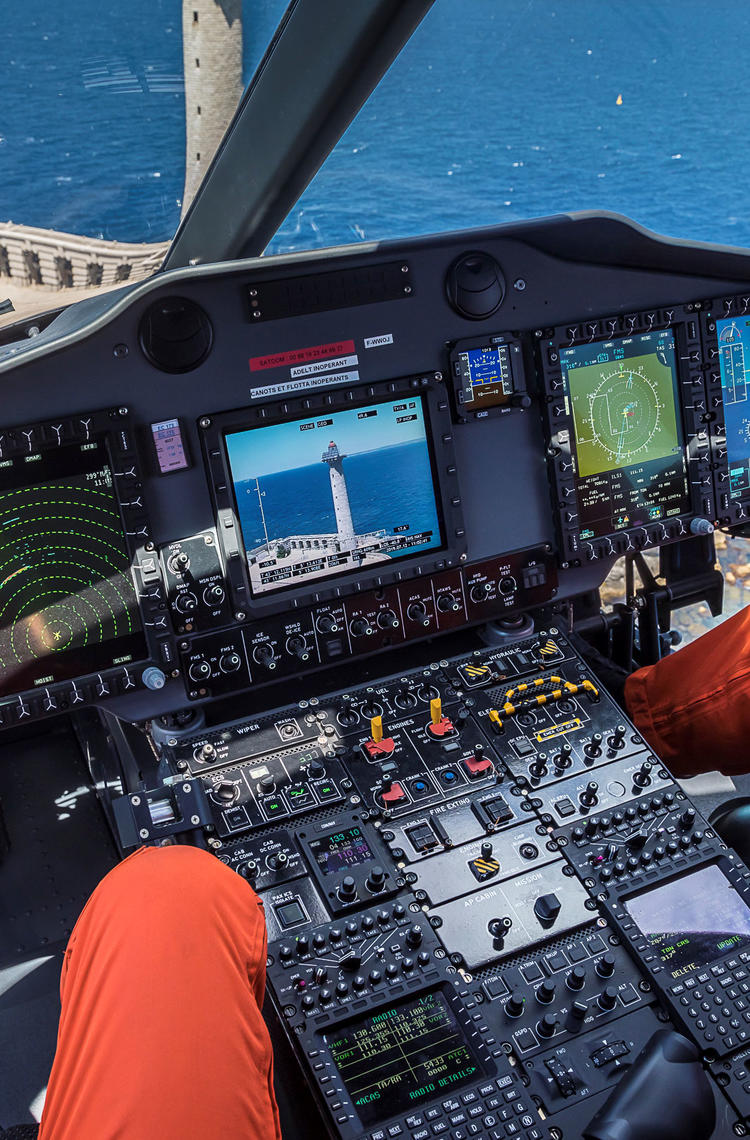
Operators of Airbus commercial airliners and helicopters alike now have the ability to operate safely into airports and heliports respectively with 3D precision, independently of ground-based infrastructure. This is possible thanks to global navigation satellite systems, which can provide pilots with their vertical as well as horizontal (lateral) GPS augmented with SBAS (Satellite Based Augmentation System) position during landing approaches.
“Point-in-Space” satellite-based operations for helicopters
As with their fixed-wing counterparts, helicopter pilots often have to deal with weather and terrain-related challenges in their operations. To address this, a form of GPS technology now allows the design of specific approach and departure procedures, known as “Point-in-Space” (PinS). These helicopter-specific procedures include a visual segment when close to the airport or helipad as well as a “Visual Flight Rules” (VFR) segment or an “Instrument Flight Rules” (IFR) segment when further out from the airport or helipad – for the latter see diagram below this section. PinS also takes advantage of the low-speed handling capabilities of a helicopter.
A big advantage of PinS technology is that it provides accurate horizontal and vertical guidance in both “controlled” or “uncontrolled” airspaces, and independently of local heliport ground-based infrastructure, thanks to GPS augmented with SBAS. This greatly enhances accessibility to helipads surrounded by buildings or terrain for example. Moreover, being an “IFR” procedure – see footnote – PinS results in fewer flight disruptions, while at the same time offering a higher degree of safety during approaches and departures in degraded visual conditions.
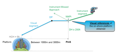
Example of a helicopter PinS approach with a satellite-guided “instrument” segment, followed by a direct visual segment.
(© EUROCONTROL)
“Satellite Landing System” for Airbus commercial airliners
The same satellite constellations – collectively known as “Global Navigation Satellite Systems” – being used by PinS described above, also enable 3D satellite-guided landing approaches (i.e. with horizontal and vertical guidance) for airlines and general-aviation operators who fly fixed-wing aircraft of all sizes.
For its part, Airbus has progressively introduced a new cockpit function called “Satellite Landing System” (SLS) which enables pilots to perform accurate approaches into airports without the need for additional ground-based systems such as an Instrument Landing System (ILS) – see footnote.
SLS also means that equipped aircraft do not have to rely on their own barometric altimeters (which are based on air pressure) as the basis for their glideslope prediction. This is possible because SLS improves the accuracy and reliability of GPS information thanks to the overlay corrections which the aircraft receives from Satellite-Based Augmentation Systems (SBAS). These corrections enable a vertical guidance of the aircraft based on geometric altitude.
As with the PinS technology for helicopters, SLS is beneficial for commercial fixed-wing aircraft when operating into airports which are not equipped with ILS guidance, and especially in low-visibility conditions and/or with surrounding terrain or other obstacles. SLS first entered service in Europe with the A350 in 2014 and is now available as well on A220, A320, A330 and A380 families.
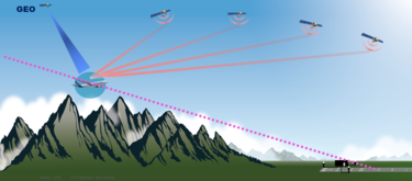
Pilot-friendly: Similar in accuracy and pilot interaction as today’s instrument Landing System (ILS)
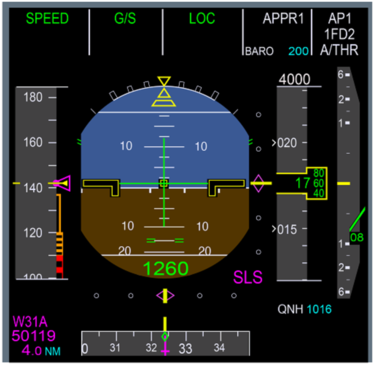
In terms of precision, SLS is similar to the traditional ground-based ILS system, though for the time being SLS can guide the aircraft down to what we call “CAT1” – i.e. to 200 ft above the ground, from where the pilot can usually see the runway. Moreover, for many secondary airports without ILS, pilots in former times would not have been able to land there at all during lower visibility conditions, but instead would need to divert to an alternate airport with better visibility. Now with SLS they can safely continue to their originally intended destination – even if the weather there deteriorates, provided that the pilots can see the runway by the time they reach the 200ft minima.
Furthermore, since the SLS function design is fully integrated into the cockpit display architecture it was possible to make it very pilot friendly. The result is that with SLS pilots don’t have to change the way they fly the aircraft because the guidance symbology presented in the cockpit (on the “Primary Flight Display” – the PFD) looks just the same as what they are already used to for an ILS approach.
More technical information about Airbus’ Satellite Landing System is also available on aircraft.airbus.com.
ILS = Instrument Landing System is a system which works by sending a VHF radio beam downrange from the runway end, with aircraft that intercept it to be guided on a continuous ‘glide-slope’ towards the runway.
IFR = Instrument Flight Rules Instrument Flight Rules (IFR) are a set of regulations under which a pilot operates an aircraft in low-visibility weather conditions. IFR are used for instrument piloting and non-visual runways.
Safety Innovation series
Continue Reading

Airspeed information, whatever the conditions
Web Story
Safety
Airbus has developed a system which improves management of unreliable airspeed events.
How to make takeoff safer
Web Story
Safety

A new workshop designed with safety in mind
Web Story
Safety
Using aircraft as sensors to prevent runway overrun
Web Story
Safety

Severe weather hazards: the best is to anticipate and avoid
Web Story
Safety
